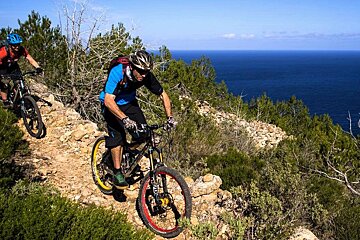
© Ride Ibiza
From Coast to Coast - Advanced Route
A tough coast to coast biking route taking in much of the north west coast
This route was the final stage of the Ibiza Mountain Bike Tour in 2009. A gruelling route that follows the coastline of the north west of Ibiza.
With some notable climbs, this bike ride will put you to the test - through narrow trails strewn with stones, tracks that meander through various valleys, hidden forest roads and two coves where you can take a dip. All of these bear witness to the arrival of the mountain bike to this island of Ibiza.
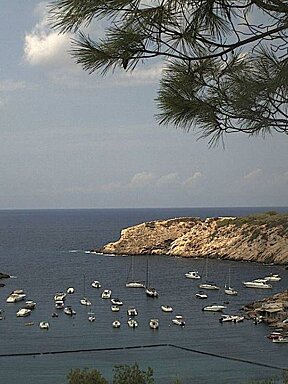
From the starting point in San Antonio you will make your way towards the lovely valley of Buscastell, before continue up a gradual climb to the top of Camp Vell at 330m. Bordering Cala d'Albarca cove through a curious narrow path that has stunning views of the scenery, you will then follow a stretch of track that takes you up to the luxurious Hacienda hotel. Passing Puerto de San Miguel and Benirras beaches the route then climbs again to the cove of Caló de s'Illaf: a mysterious spot of crystalline waters. Later in the village of San Juan the last – and hardest – climb commences and then connect later with the track that leads to the highest point on the route: Puig d'en Teixidor, at 352 metres. Finally, going down to Can Truy, a place near Santa Eularia, where this route ends.
Who should go
This is a difficult and long endurance route that is only for expert riders.
What to see
Apart from the many beaches and coves along the route you will enjoy many scenic view points on the coastline cliff tops.
Where to lunch
The beaches of Puerto de San Miguel and Benirras both have good beach front restaurants - and both are great options to stop for a swim too!
Directions
1. Departure. We depart from the Sant Antoni roundabout next to the seafront promenade, in direction of Eivissa. When we reach a roundabout, we turn to the left; at the next roundabout, we turn to the right, in the direction of Santa Agnès.
2. At the crossroads, straight ahead. At a curve in the road, we continue straight on, changing roads.
3. At crossroads, straight ahead onto the track. We reach a crossroads and we continue straight, onto a track. We follow this track for 3.5 km, passing through the Buscastell valley, where we will stop at the es Broll spring.
4. At the crossroads, straight ahead. The track crosses with a road, but we continue straight on the dirt track; 1 km later on, we reach another crossroads; we turn to the left, then to the right onto a dirt track.
5. At crossroads, straight ahead. At this crossroads, next to a house, we continue straight on, up a road that climbs. We reach a level area, where we turn to the right; a bit further on, we also turn right, following the same road.
6. Right turn at crossroads. We reach a crossroads and we continue on the right. Later on, we also continue on the right, without climbing to the top; at the next crossroads (which crosses a track), we go to the left.
7. Rightfork. We take the right legs of this bifurcation and the next one. At the following crossroads, we continue straight on, staying on the same track up to th road.
8. Left turn at crossroads. When we reach the road, we turn to the left. Approximately 1 km later, there is a house with yellow windows; we turn left onto a dirt track.
9. Right fork. We reach a very clear fork, from which we can contemplate Cala d'Albarca; we continue on the right. Next, we arrive at a crossroads and continue straight onto a path. At a crossroads 100 metres on this trail, we climb to the right.
10. At crossroads, right turn onto the track. We reach a track and we continue on the right, still going down. Further on, we turn to the left and then to the right at the bifurcation, following a road.
11. Right urn onto the path. At this point, we turn right onto a path that descends a very steep slope through the forest. We reach a track and turn to the right; we pass a house and, a bit further on, we turn to the right at the next crossroads.
12. Left turn at crossroads. When we come out at the road, we turn to the left. 150 metres later, right next to some curves that ascend, we turn to the right onto a track that heads down.
13. Right fork. At the fork, we continue to the right in our downward direction. At the next crossroads, we continue on the left; at the following two crossroads, we go straight on a stone road.
14. Right turn at crossroads. We reach a crossroads near the Hacienda hotel and turn right. Further on, we reach a road; we descend to the right, to Port de Sant Miquel.
15. Left turn at crossroads. We turn to the left at the crossroads; then turn right towards Benirràs, before reaching Port de San Miquel.
16. Right turn at crossroads. At the crossroads next to Benirrás beach, we turn to the right. 200 metres further on, we turn left onto a hard stone road. At the next crossroads, we turn to the right and then to the left.
17. Right fork. When we reach a fork, we continue to the right. We then continue straight on the main road, without turning.
18. Right turn at crossroads. Next to Caló de s'Illa, there is a crossroads where cars usually park; at this point, we continue to the right. Further on, we connect with a road, where we continue straight ahead.
19. Turn to the right onto the track. We then turn right onto a dirt track that climbs; we continue straight on this track. At the next three forks, we continue to the left.
20. At crossroads, straight ahead onto the road. We reach the highest point of this climb and then begin to descend on a road. When we reach another B road later on, we turn left.
21. Left turn at crossroads. We reach a crossroads and turn to the left. Just a bit further on, we turn to the left onto a track until we connect with another road; we then continue on the left to Sant Joan.
22. Right turn at crossroads in the village. We reach the village of Sant Joan and turn to the right to cross the village; we then connect with a trail going east. We go through a small tunnel and continue straight east on a track, until we connect with an upward trail next to a house.
23. At the crossroads, right turn onto the track. We reach a road, which we cross straight ahead; we continue on a track on the right. 200 metres further on, we turn to theleft onto a stone road. At the next fork, we continue to the left.
24. Left turn at crossroads. We reach a crossroads next to a water tank; we continue to the left, beginning to descend. We continue going down this track; at the next two crossroads, we continue to the left.
25. At crossroads, right turn onto the road. When we reach a B road, we turn right; next, we turn left towards Atzaró. We go straight on for the next 2 km.
26. Right turn at crossroads. At this crossroads, we turn right; after a small bridge 1 km further on, we turn left at the crossroads.
27. Right turn at crossroads. We reach a crossroads and turn to the right; we continue straight on until the Can Truy restaurant. At this point, we turn to the left onto a track.
28. End of the itinerary. The route finishes by to the Can Truy bike circuit.

